By R.Swathi
I remember my childhood days spent gazing at the sky, counting clouds, and imagining their shapes—a witch, a bunch of grapes, or the layered sands of a desert. They are nature’s wonder – feeding our imagination and quenching our thirst.


Did you know that the study of clouds is called nephology, a branch of meteorology that explores the formation, development, dissipation, types and effects of clouds. Clouds are classifieds based on their shape and height. The three main cloud types based on shape are:
- Cirrus (Curly): These are high-level clouds, appearing as thin, wispy strands. They’re made of ice crystals and often look like delicate feathers or streaks across the sky. They typically indicate fair weather.
- Cumulus (Piled up): These are the classic, puffy, white clouds that look like floating cotton balls. They form at low to mid-levels and often have flat bases and domed tops. They usually signal fair weather, but if they grow tall and dark, they can become storm clouds.
- Stratus (Layered): These are flat, layered clouds that look like a uniform gray blanket covering the sky. They often bring light drizzle or mist and can make for a dull, overcast day.
There is another type, which is a combination of all the three – Nimbus (This reminds me of Harry Potter’s broom). The vast majority of precipitation occurs from nimbo-form clouds and therefore these clouds are generally the thickest.
Based on their altitude, clouds are classified into High-level clouds (above 20,000 feet), Mid-level clouds (6,500 to 20,000 feet) and Low-level clouds (below 6,500 feet).
By looking at the cloud itself, one can get a good sense of the current weather.
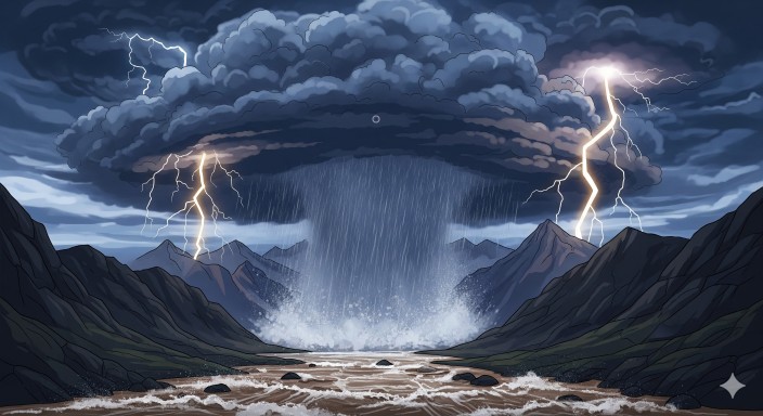
Among all the cloud types, the Cumulonimbus (Cumulus + Nimbus) is the most dangerous. Towering across levels, it brings thunderstorms, lightning, hail, strong winds, flash floods—and sometimes, tornadoes.
So, why are we talking about clouds now? Well, on Aug.30, the locality of Manali witnessed the might of such a cloud. A cloudburst unleashed 106.2 mm and 126.6 mm of rain within two consecutive hours. A cloudburst is an extreme downpour of over 100 mm of rain over a small area (20–30 sq km) in about an hour. They happens when a cumulonimbus cloud stalls over an area. The rain that falls from this cloud is not dispersed by winds, so it all falls in a concentrated area, leading to an exceptionally high amount of rainfall in a short time.
Though rare in coastal regions, cloudbursts are becoming more frequent in Chennai. Experts suggest this may be nature’s response to unchecked urbanisation and climate change.
As we marvel at clouds for their beauty, we must also heed their warnings. They remind us that true progress lies not in unchecked growth, but in finding balance between urban development and respect for nature’s rhythms.